
Description
 Day 1: Wednesday – Windhoek – Swakopmund – Hotel A La Mer – 370 km
We take an unguided local shuttle service this morning from Windhoek to the small seaside holiday town of Swakopmund. Collection from your accommodation within the Windhoek city limits will be from 06:00. Journey time is around five hours and you will be dropped off at the Hotel A La Mer where you will have a reservation. Hotel A La Mer is centrally located and Swakopmund is easily explored on foot from the hotel.
Swakopmund is an interesting place to say the least, founded by Captain Kurt von François of the imperial colonial army of the German empire in 1892. (He also founded Windhoek in 1890). The town is bound to the north, the east and the south by the mighty sand dunes of the Namib Desert and to the west by the Atlantic Ocean. There are still many examples of colonial German architecture to be seen and the German language is still widely used.
Swakopmund also offers many opportunities to keep us busy during our time here with the many extra, optional activities that are available. Scenic flights over the desert are very popular and for the more adventurous perhaps try sky diving or quad biking over and in the Namib dunes.
Chameleon Safaris will discuss all the options with you in advance and will be able to facilitate any bookings that we would like to make.
Lunch and dinner tonight are for your own account, Swakopmund boasts some truly excellent restaurants and again Chameleon will be able to help you with recommendations and bookings.
Accommodation: Twin share rooms, en-suite bathroom
Meals: None.
Day 2: Thursday Hotel A La Mer, Swakopmund
A full day here in Swakopmund and there are many ways to enjoy this remarkable little town. A lie-in, a big breakfast and a wander around town might well be the order of the day. There are some great curio shops, excellent book shops and there is a real café culture going on here with plenty of small eateries serving delicious food.
If that all sounds a bit tame then the scenic flights, sky diving or quad biking are all still on the menu but now we can add in several other options that are available in the mornings. This could be sand boarding if you fancy careering down the slip face of a sand dune at 60 km per hour. There are two sand boarding options, quite simply ‘lie down’ or ‘stand up’.
If you have a bit snow-boarding experience, then the stand-up version is for you. If not, then go for the lie down option, no experience required and thrills & spills are guaranteed.
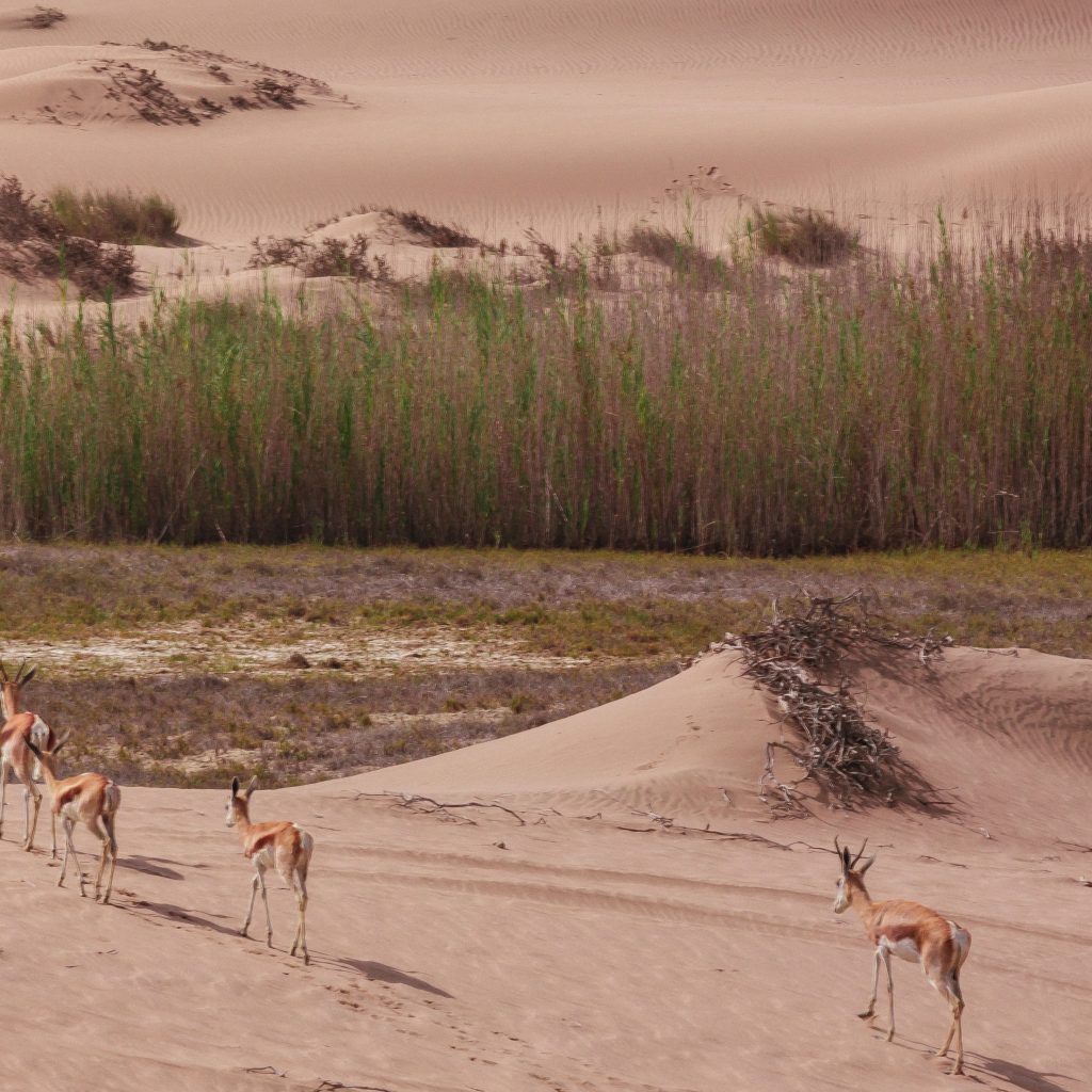
For the more leisurely minded there are bicycle tours, horse riding trips, camel riding trips and the very popular ‘living desert’ excursions. Here you will join a group in a vehicle with a specialist guide who will take you into the sand dune sea and introduce you to some of the amazing creatures and plants that survive in one of the toughest environments in the world.
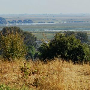
The port town of Walvis Bay, (Whale Bay), is just 40 km along the coast to the south and is the departure point for two other great activity options. Walvis Bay lagoon is an internationally recognised Ramsar site, (Convention on Wetlands of International Importance Especially as Waterfowl Habitat) and is justly renowned for its birdlife. Flamingo, pelican, African oyster catcher and turnstone to name but a few of the more than 50 bird species occurring here. This with other aqua fauna including bottlenose and Heaviside dolphins, humpbacked and southern right whales, ocean sunfish and Cape fur seals all add up to make Walvis Bay lagoon being a wetland wonderland.
Guided lagoon boat trips are a great way to find many of these species, cruising on luxury catamaran sailing boats right out to where the calm lagoon water meets the mighty Atlantic Ocean at Pelican Point.
If you would prefer a more physical introduction to the lagoon there are ocean kayaking trips available. Travelling in 4×4 vehicles out to the launch site at Pelican Point lighthouse, you can often get much closer to the wildlife under your own steam.
There is also the opportunity to visit Sandwich Harbour, also a Ramsar site and an area of outstanding natural beauty. Departing from Swakopmund the round trip is about 200 km and the route takes you across the flood plains, over the coastal dunes and along the beaches into the Kuiseb River Delta.
The harbour first appeared on Portuguese navigational charts in the 15th century and was then called Port d’ Ihelo, but then turned up as Sandwich Harbour on a chart published by the British East India Company in 1791. It is reasonably inferred that the Name Sandwich comes from a survey and whaling ship named Sandwich, a ship which belonged to the fleet of the 16th century British whaling company Samuel Enderby & Sons. The Sandwich was engaged in operations in the area around 1785.
Sandwich Harbour has seen much human industry and endeavour over the centuries but is not a working harbour. The harbour entrance is subject to the vagaries of the Atlantic and the mouth of the harbour tends to silt up, as it is now and as it has been for many years. History tells us that strong currents and tides can and do sometimes open the harbour mouth but, when open it is dangerous to enter with a ship as it can quickly close again. Indeed, in the olden days the British Admiralty sailing notes advised ships captains not to enter Sandwich without sufficient dynamite on board in case they had to blow up the silted harbour entrance if they were unlucky enough to get trapped inside.
The excursion to Sandwich is a day of sand, sea, sun, (hopefully), and fun. It is a day of amazing scenery, towering sand dunes and a wee bit of adrenaline as your guide will roller coast you through the dunes on the return leg of the trip.
Chameleon Safaris will discuss all the options with you in advance and will be able to facilitate any bookings that we would like to make. We will also meet our safari guide and fellow travellers coming into Swakopmund from Etosha and who will be joining us on our forthcoming adventure to the south.
Lunch and dinner are for your own account today, although most of the optional excursions have lunch, or some form of snacks included in the price.
Accommodation: Twin share rooms, en-suite bathroom
Meals: Breakfast
Day 3: Friday – Swakopmund – Sesriem – 350 km
Making the most of our time at the coast we only leave Swakopmund this morning at 11:30, giving us plenty of time for a wander around town and last minute shopping. If you haven’t by now had enough of Swakopmund adventure there is also time for another activity if you wish.
Departing Swakopmund no later than 11:30 we head east into the desert. We first cross the Namib gravel plains, large areas of flat and seemingly barren terrain broken up by huge mountain inselbergs. We have two mountain passes to traverse this afternoon, first is the mighty Kuiseb Pass and we follow the road from the top of the mountains, dropping steeply down into the canyon carved over eons by the Kuiseb River on its way to debouch into the ocean at the port town of Walvis Bay. We climb up from the banks of the river and over the pass, travelling through the mountain peaks and on to the second, smaller canyon of the Gaub River, a tributary of the Kuiseb. We emerge from the mountains onto a flat road and almost immediately we cross the Tropic of Capricorn at 23.5 south degrees. There is a signpost at this auspicious spot and we stop along the road for photos.
From here we continue on through the desert landscape to the tiny town of Solitaire where we can stretch our legs and sample the apple pie that has made this homestead famous. Onwards again to our destination for today, the gateway to the dunes and Sossusvlei at Sesriem.
We make our campsite in anticipation of our day tomorrow, in the shadow of the towering red dunes of the world’s oldest desert.
Accommodation: Twin share tents, shared ablution at campsite.
Meals: Breakfast, Lunch & Dinner
Day 4: Saturday – Sesriem – Sossusvlei – Sesriem – 120 km
Sunrise in the dunes is the name of the game this morning and that means a pre-dawn start. Our first stop will be at Dune 45, so named because it is 45 km from Sesriem, and we cover this first distance in darkness and early morning twilight. The best time to photograph the dunes is around sunrise and sunset. This is when you can see towering sand dunes illuminated a glowing orange, apricot red on one side and swathed in shadow on the other. The depth of field is amazing at this time of day.
We arrive at Dune 45 and climb to a vantage point for sunrise, watching as the colours grow and change with the ever-altering light. Back to the vehicle for a quick breakfast and we carry on for the last few kilometres to the 2×4 car park where we board the 4×4 shuttle vehicles into the vlei. From here we enter the ancient Tsauchab River-bed for the last 5km leg to Sossusvlei itself.
The Tsauchab River is ephemeral, it only flows seasonally, when there is enough rain, and for the most part the river-bed is dry. Eons ago, during these rare floods the Tsauchab sometimes received enough water to flow all the way to the Atlantic Ocean. However, as the millennia passed and the dune fields began to form, (around five million years ago), wind -blown sand invaded the river-beds. The rivers became more and more constricted by sand until eventually the occasional floods could not break through the sand barriers that had been erected by the wind. The valley we drove along this morning in the darkness is kept free of sand by the Tsauchab but Sossusvlei is now permanently waters end. Sossusvlei does still sometimes flood, (perhaps once in a decade). After good rains in the Naukluft Mountains where the river rises, Sossusvlei can become inundated, and the lake that this creates can last for many months, but no longer can the river find its original path to the Atlantic.
The 4×4 shuttle service will transport us through the sandy terrain of the river-bed. We will visit Dead Vlei on foot led by our guide, an ancient pan completely surrounded by sand, that is strikingly populated with dead, skeletal camelthorn trees. These trees have been a feature on this landscape for over 1000 years. Sossusvlei is almost surrounded by dunes, just one narrow path kept open by the Tsauchab River. We have time to explore the area on foot and to climb one of the highest dunes in the world, some towering 300 m above us, the views are breath taking and justly famous.
We drive back to Sesriem for lunch and perhaps a dip in the swimming pool and in the afternoon we take a short excursion to see the Sesriem Canyon.
Only four km from our campsite, this canyon has been carved out of the landscape by the Tsauchab River. Around two million years ago there was an ice age in Europe. This caused glaciers to form and resulted in a worldwide drop in sea level. The knock on effect of this at Sesriem Canyon was that it increased the length and waterflow of the Tsauchab River. This greater force of water allowed the Tsauchab to begin cutting through the terrain resulting in the canyon we can see today. We can easily walk into the river-bed, it is usually much cooler in the canyon and we can follow the river for some way along its journey to Sossusvlei.
In the late afternoon there is one further option with which to close our time in the world’s oldest desert. A short drive will take us to Elim Dune, for the best golden light before sunset. From here, if you would like to, it is a relatively short walk back, through the desert, to our camp.
Accommodation: Twin share tents, shared ablution at campsite
Meals: Breakfast, Lunch, Dinner
Day 5: Sunday – Sesriem – Klein Aus Vista – 350 km
We have a scenic drive today through ever changing desert scenery, mountains and open grassland. We are continuing our long drive south and our destination is the tiny community of Aus, located in the Aus Mountains above the plains of the Namib Desert.
Aus was formally the site of a prisoner of war camp set up by the South African army to house German prisoners during the second world war.
Our actual destination today is Klein Aus Vista located just outside Aus and just inside the private Gondwana Sperrgebiet Rand Park. We aim to arrive in the early afternoon and set up camp, giving us time to stretch our legs on the un-guided hiking trails on the property.
The landscape is wide open vistas and we are hoping for a spectacular sunset.
Accommodation: Twin share tents, shared ablution at campsite
Meals: Breakfast, Lunch, Dinner
Day 6: Monday – Klein Aus Vista – Luderitz – Klein Aus Vista – 250 km
We again start early but with the luxury of a proper sealed tar road today. We travel through grasslands and wide open desert scenery on our easy drive towards the ocean.
Desert adapted horses run wild in this area and we need to keep a good look out for these amazing creatures. Horses are not a part of the true desert ecosystem and their origins here remain open to speculation. Perhaps they are descended from the German cavalry lines during the first world war. It is also documented that Hans Heinrich von Wolf, owner and resident of Castle Duwisib in 1909 was a keen horse breeder. Maybe the origins of the horses today come from his blood stock escaping their stables at Duwisib. Whatever their true history it is a privilege to see these animals in their wild habitat.
We are en-route to the ghost town at Kolmanskop, located about 15 km from the port town of Luderitz. For centuries, amongst early mariners, there have been rumours and stories of untold riches to be found on one far flung coast or another. Most often these claims turned out to be just stories but in the case of the far south-west of Namibia, it happened to be true. When diamonds were first discovered here you could literally walk along the beach and fill your pockets with these precious stones.
The first diamond mine was called Kolmanskop. Founded in 1908, it was built in the architectural style of a German village and was supplied with the most modern amenities of the age. There was a hospital that boasted the first x-ray machine in the southern hemisphere, a power station, school, ball room and ice factory. The decline of Kolmanskop started around 1920 when the diamonds began to run out. Then in 1928 the richest diamond deposits that the world had, at the time, ever known were discovered 270 km away to the south at the Orange River. Kolmanskop became deserted and so started the slow reclamation of the town by the desert.
Still a striking sight today, we will stop at Kolmanskop for a guided tour of the town and the opportunity to photograph this unique and interesting site.
On departure from Kolmanskop we quickly cover the last few kilometres to Luderitz itself, well known for its unique and colourful colonial-style buildings. We drive out on to the Luderitz peninsula and enjoy the scenery on way to the historical monument at Diaz Point. As at Cape Cross, the first sign of European interest in this land was from the Portuguese and in this case it was the navigator Bartolomeu Diaz who landed here in 1487 and caused a stone cross to be erected. This time the name given to the area was Angra das Voltas or ‘Bay of Tacks’ with reference to the many times Diaz had to ‘tack’ his ship against the southern gales. Luderitz is still today one of the windiest places on planet earth, so some things at least have not changed over the centuries.
We head back to our accommodation at Klein Aus Vista, taking a second opportunity to see the desert horses and arriving in time for a sundowner at Klein Aus Vista.
Accommodation: Twin share tents, shared ablution at campsite
Meals: Breakfast, Lunch & Dinner
Day 7: Tuesday – Klein Aus Vista – Quiver Tree – 550 km
A long drive today but we take advantage of the tar road for the first part of the morning. We are heading east but we will soon turn south again to complete our traverse of Namibia’s southern region. Our first main stop this morning will be the incredible Fish River Canyon located in the /Ai-/Ais Richtersveldt Transfrontier National Park. We enter the park at the Hobas gate and from there it is only a short drive to the main lookout point over the Fish River Canyon.
Second only in size to the Grand Canyon in Arizona, the vistas across this most immense of nature’s sculptures are breath taking. From our vantage point high up on the plateau we overlook the so called ‘Hell’s Bend’ which takes the form of a huge meander along the course of the Fish River.
The canyon itself is around 160 km long, 27 km wide at its widest point and in places 550 m deep. The origins of the Fish River Canyon can be traced back to about 1,800 million years and the formation of the canyon itself can be attributed to just about every possible geological force known to man.
Huge seismic forces, volcanic eruptions, earthquakes, glacial activity, relentless erosion of every kind and finally, deepened by the Fish River that we can see glinting in the sunlight far below us. This is a perfect example of tortured rock that inspires our awe by its sheer massive size.
It is hard to leave such an impressive sight but we journey onwards, turning our heads to once again to the north as the canyon marks the end of the southern leg of our trip. We are en-route to Keetmanshoop, the main commercial and political centre of Namibia’s south. A short stop here and then on to our overnight camp at the Quiver Tree Forrest.
Quiver trees are Namibia’s National Tree and are so named because the San tribes of Southern Africa used to strip the scaly bark from these trees and construct from it a narrow cylinder. From this they would manufacture a quiver in which to keep their poisoned arrows. A quiver tree, despite it’s very tree like appearance, is in fact not a tree at all. It’s real name is Aloidendron Dichotomum, (formally Aloe Dichotoma), and so is an aloe, and an aloe is a plant and not a tree. This does not diminish the impact they have on the landscape, weird and wonderful shapes abound from this collection of around 250 quiver plants/trees/aloes? The oldest specimens here are estimated to be about 200 years old and it is thought that they can achieve an age of up to 300 years. Dating a quiver tree however is difficult, as it does not have rings of bark to count, the centre of the tree is fibrous and there is really no established method of ageing.
This is the last night of our safari and time to reflect on our amazing adventure as we sit around our camp-fire one last time.
Accommodation: Twin share tents, shared ablution at campsite
Meals: Breakfast, Lunch, Dinner
Day 8: Wednesday –Quiver Tree forest –Windhoek 500 km
We head north today and we have the luxury of the main tar road for our whole journey, no gravel road ‘African Massage ’to contend with, as we head back to Windhoek.
Namibia is so rich in interesting things that it is impossible drive for any great distance without passing places of interest and there are several worth mentioning along the way today.
After about 80 km from Keetmanshoop, in the distance and off to the west we can see a tall mountain peak. This is Brukkaros, another volcano but quite an unusual one. Brukkaros was formed around 180 million years ago when molten magma from deep below the surface was pushed upwards until it intruded into the overlaying, relatively soft, sedimentary formations that made up the surface. Molten magma intrusions are common in world-wide geology, but what makes Brukkaros unusual is that in this case the upward moving magma hit an underground lake leading to a huge explosion powered by super-heated steam.
What was left formed hollow cave, that was once the magma chamber, but with an overhead ‘caldera’ forming a partial roof. 80 million years later the weight of the caldera was too much and collapsed into the magma cave. Brukkaros is 1,590 m tall at its highest point, the collapsed caldera measures about 4 km in diameter. The mountain itself is 650m higher than anything else in the area and the crater floor is 350 m below the rim. Steam formed volcanoes are very rare, and although Brukkaros is too far away to be included on this itinerary it is an interesting landmark to look out for on our drive today.
About 150 km into our long road today we will pass a signpost to a place called Gibeon. Again, like Brukkaros, Gibeon is too far away to be included in this itinerary, but there is an interesting story that is worth telling.
Near here, in ancient prehistoric times, the area around what is now Gibeon was subjected to a Meteor strike of very significant proportions. The meteor, when intact, was thought to measure 4 x 4 x 3 meters and we know that it was made of solid metal. As it entered the earth’s atmosphere the metal began to melt and in due course the meteor fragmented in a huge explosion scattering chunks of molten metal across the countryside. Meteor’s from this event have been found as far away as Brukkaros Volcano to the south and as far away again towards the north, but the greatest concentration of meteor material has been found in and around Gibeon. If you have time in Windhoek after our safari it is worth going to Post Street Mall in the city centre where you will find a public display of Gibeon Meteorites
Still heading ever north our journey today takes us through the small centres of Mariental and Rehoboth and we will stop along the road today for a light lunch. We aim to be back in Windhoek in the late afternoon.
There will be a shuttle service to take you to your accommodation within the Windhoek City limits.
We recommend that departure flights are not scheduled for today.
Accommodation: None
Meals: Breakfast, Lunch


Reviews
There are no reviews yet.